
A collage of carvings and inscriptions of different periods has pointed that this extraordinary heritage is on the brink of destruction on the proposed site of the Diamer-Basha Dam.
The mountainous region of Pakistan which lies between the western Himalayas, the Korakoram in the east and the Hindukush in the west. Here, the junction of the ancient routes made the upper Indus a cradle and crossroads of different civilizations.
Invaders, merchants, pilgrims, travelers, researchers and artisans from different origins, religions, times, eras and cultures used the legendary silk route and its branches to enter in the region. Many of them left their cultural and religious signs on the rocks, boulders and cliffs.
The sun-tanned smooth rocks attracted more visitors and settlers to carve their own signs, symbols, inscriptions and artworks on the same locations. And hence, gradually a rock art archive accumulated in the area and eventually became a wonderland of some 50,000 rock carvings and 5,000 inscriptions from different civilizations ranging from the eighth millennium BC to the coming of Islam (since the 16th century AD) in the region.
The diversity of the rock carvings in the region turned the area into one of the most important rendezvous of petroglyphs in the world.
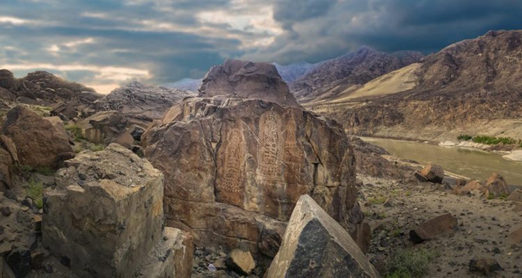
The Shatial, Thor, Hodur, Thalpan, Naupura, Chaghdo and other sites of northern Pakistan having clusters of carvings but the Basha-Diamer area holds thousands of very important rock carvings.
The site represents hundreds of inscriptions in Brahmi, Sogdian, middle Persian, Chinese, Tibetan and even ancient Hebrew languages. Some 80 per cent of the writings are in Brahmi language.
These writings not only provide insights into the religious and political situation but also show the name of the rulers and a rough date of the time. These details of the inscriptions helped the experts arrange them chronologically.
In 1884, a Hungarian traveler, Karl Eugen discovered a Buddhist carving in present Baltistan. In 1907, a veteran explorer, Ghulam Muhammad unveiled another Buddhist petroglyph from the Diamer district.
When the 750 km long, Karakorum Highway (the modern Silk Road) inaugurated in 1978, thousands of more engravings came to view which inspires a German scholar, Karl Jettmar to further explore the rock art wealth.
In 1980, Karl Jettmar and Pakistan’s father of archaeology, Ahmed Hassan Dani launched a Pak-German study group to systematically investigate the ancient rock art in the region.
Another research project entitled “Rock Carvings and Inscriptions along the Karakorum Highway” was initiated in 1983. The Heidelberg Academy of Humanities and Sciences and the Department of Archaeology of Gilgit were responsible for the study group. Professor Harald Hauptmann has been the head of the project since 1989 as a successor of Jettmar.
in the third millennium BC, agriculture started in the region and carvings of horses were observed for first time. Then in the beginning of the first millennium BC, the area witnessed invasions by new ethnic groups such as the Sakan tribes. They carved sketches of Eurasian animals, most of them very interesting, bizarre and mythical in nature.
Later, another bunch of carvings appeared representing more mythical creatures, horses and warriors with Persian attire. These depicted the Iranian influence in the region and the expansion of Achaemenid Empire in sixth century BC.
In the first century AD, Buddhism emerged in the area as new belief system and reached its peak between the fifth and eighth century. Many spectacular carvings of Buddha and stupas – sacred buildings – and related inscriptions were found carved in the same era.
According the Hauptmann, the historic period of early Buddhism started from this area because of findings of old Indian style Khorashti language or Sanskrit. The venerations of Buddha and names of different kings show the climax of Buddhism in this area.
Although addressing Pakistan’s energy crisis is an urgent need and the Basha Dam would help bridge the gap between the demand and supply of power, the conservation and mitigation of these carvings is also very important.
When asked Hauptmann about mitigation of the rock carvings in one hand and the need of the dam on the other, he said, “We (as an archaeologist) have to respect the decision (to build the dam) but it is very sad for us to lose one of the most rich and diverse rock art provinces of the world.”
According to Hauptmann, the Basha Dam will drown 32 villages and displace more than 25,000 people.
He added that some 3,000 very important stupas and similar number of drawings will be submerged after the construction of the dam. He called to establish a cultural center in Gilgit where original and replicas of the carvings could be preserved along with scientific documents about the geography, history, languages, music, wildlife and other aspects of the northern areas.
This center could be a rendezvous for scholars, writers, visitors and for future generation to discover the exciting history of the region.
This area is also famous for the amazing story of mysterious gold-digging ants.
The creatures piled up the dust and dirt while digging up the burrows where people would collect them to extract gold.
In 1854, Alexander Cunningham mentioned the fact that “the sands of the Indus have long been celebrated for the production of gold.”
Leave a Reply